Many a historian and idle daydreamer has longed for a time machine. Unfortunately, the lack of visitors from the future suggests that we are destined to satisfy our curiosity with what past generations have left us: the yellowed clippings, the fragile photographs, and the fading memories that we often encounter in our quest to connect the past to the present.
In other articles, I’ve noted that over time, old photos often undergo a sort of inversion, in which the odd details in the background become much more significant than the intended subject. In some photos, zooming in to this latent detail can almost feel like stepping into the scene.
Previously we’ve explored the likely extent of the former town of Rawsonville, Michigan, and also taken some excursions to examine some of its nooks and crannies. So far, we have only contemplated the ghosts of Rawsonville from the air, via old maps and aerial photos, or visited the thick forest that has taken much of its place. But thanks to several tip-offs and contributions from some readers, we can now consider a number of sources that allow us to come much closer to stepping into the Rawsonville that was.
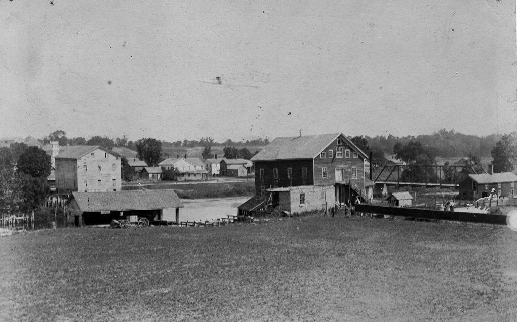
To begin our stroll, we step into a crisply detailed scene taken from the mill ground south of the river, in about 1890. Although this scene is already well known to local historians, it has a history of being reproduced very poorly — it can be found in a badly exposed version in the Ypsilanti historical archives; it also appears as a tiny halftone illustration in Horste & Wilson’s 1976 history book Water Under the Bridge; and it occasionally surfaces in old newspaper clippings.
Here, however, we benefit from the gracious contribution of Pam, a reader whose family has Rawsonville connections, and whose grandmother preserved and annotated this image. Judging from the clarity and resolution, it must be an early-generation reproduction, or possibly even the original print — one whose detail we can practically step into.
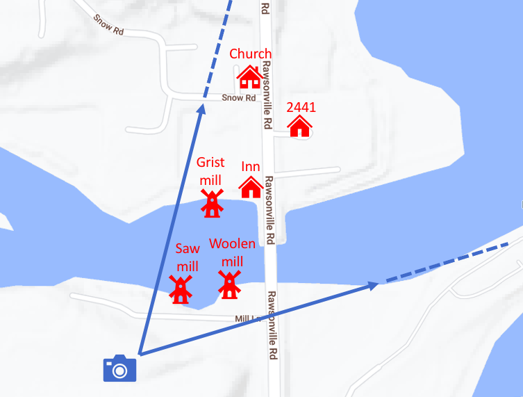
This image is so rich with information that we will examine it in four separate sections, to give it the attention it deserves. But first, for context, I’ve attempted to approximately locate the scene on a current map of the area, as seen below. The photo was taken from somewhere on the south side of the river to the west of Rawsonville Road, approximately where Mill Lane is indicated on the modern map. The area where the photographer was standing is completely overgrown with mature forest today, with the exception of Mill Lane itself, which was recently cleared as part of utility work, making it once again visible on aerial photos, although it is still gated off as it has been for decades.
Starting from the left, in the scene below we see a large flour mill of at least four stories, seemingly extending out on pilings from the north bank of the river. Somewhere far below, a water wheel would have met the water, and a complex network of belts, rotors, and pulleys would have conducted the power of the Huron River throughout its four stories, producing commercial quantities of flour and feed. Somewhere near the water, aging docks would have been situated to load and unload products to and from river barges, that were the primary form of freight transportation at the time of its construction.
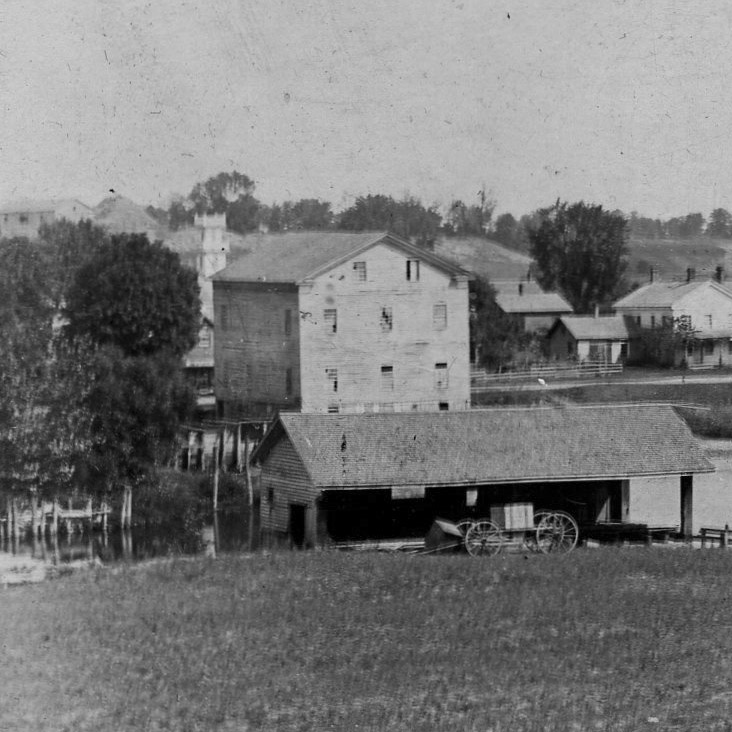
But by the time this photo was taken, the river barges were swiftly becoming a thing of the past, as the railroads had come to Washtenaw and Wayne counties a decade before, but not through Rawsonville. We are probably seeing the mill in the last years of its viability, its four stories of millstones, grain separators, and bagging equipment providing capacity for far more business than the rapidly declining barge trade could ever supply again.
Far behind and to the left of the grist mill, we can see a gleaming white tower in the distance. This could only be the spire of the small church that used to exist at the northwest corner of Rawsonville and Snow Road. We’ll see it up close in a later picture.
In the foreground, on the south side of the river, the long building is a sawmill identified in the caption as “saw mill (Fell’s).” A carriage has been loaded with what, perhaps, we might imagine as a bundle of shingles or something similar. Oddly, another bundle or crate seems to have tumbled off the front of the carriage. Is this a going concern, or a decaying ruin? It’s hard to tell. Perhaps it’s just a trick of the light.
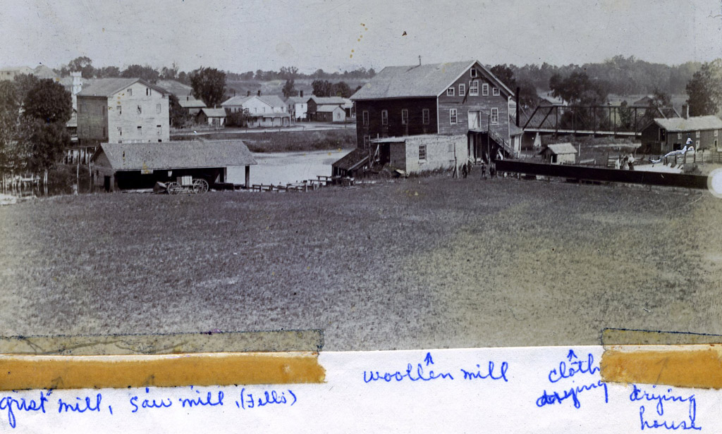
Below, we have panned to the right, to examine the view across the river. This peek-a-boo view of the main street seems to confirm that the business district of Rawsonville was a scattered collection of detached frame structures, as was typical for small villages of the time. The large house with three chimneys, just left of center, is the Rawsonville Inn, also known by some accounts as the Rawsonville Tavern. Its building survived for some time, and we will see it again later.
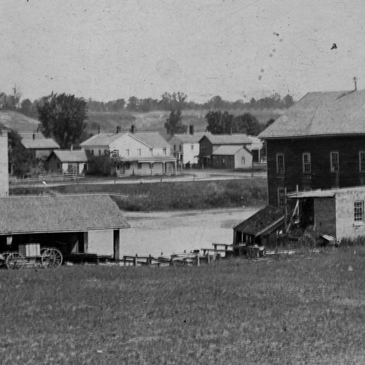
To the immediate right of the Inn, across Rawsonville Road, the white building with the tall chimney bears a striking resemblance to present-day 2441 Rawsonville Road, a private residence that is known to date to this time. Beside it are a couple of frame structures, possibly attached to each other. In Water Under the Bridge, a caption found on a different photo identifies these buildings as the C.J. Barlow store and the post office, with justice of the peace upstairs.
Below, panning further to the right, we see the Rawsonville woolen mill. Contemporary references say it had five stories, three of which we can see here. The two floors below likely would have extended down to the water, housing the water wheel and its main shaft, and providing loading docks to meet the river barges. Like the flour mill, this building likely would have been constructed at least partially on wooden pilings, to interface with the water and traffic flow on the river.
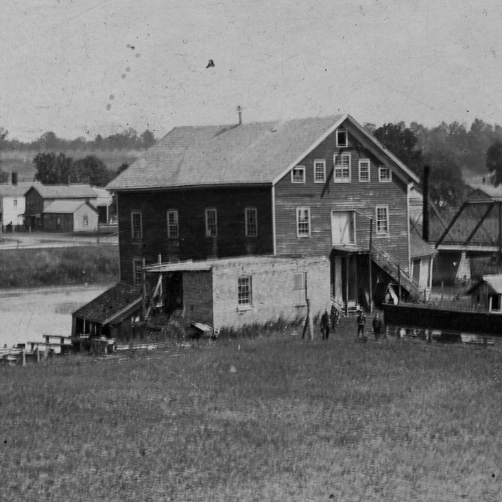
Panning finally to the far right, below we see the old, iron-framed Rawsonville bridge. But what’s the long strip of black in the foreground? The caption indicates that the proud people standing nearby are showing off a long bolt of freshly made woolen fabric, where it is apparently drying in the sun. The caption also points to the modest structure to the right, calling it the “drying house,” where fresh woolen product presumably would have been left to dry. It seems rather odd that this building devoted to the drying of wet fabric did not seem to have a lot of ventilation, except for the few visible windows. Perhaps the large chimney at its center indicates that heat was part of the process.
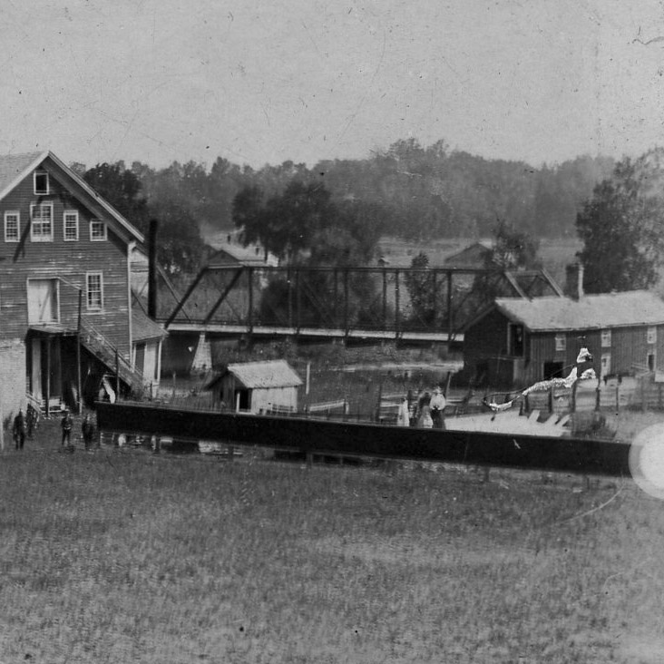
We can also see a scattering of structures in the distance beyond the bridge, suggesting that there was indeed some habitation on the east side of Rawsonville. Although we have already established in another article that most of Rawsonville was not actually inundated by Belleville Lake, some of that flat plain behind the bridge is likely underwater today.
The deserted village
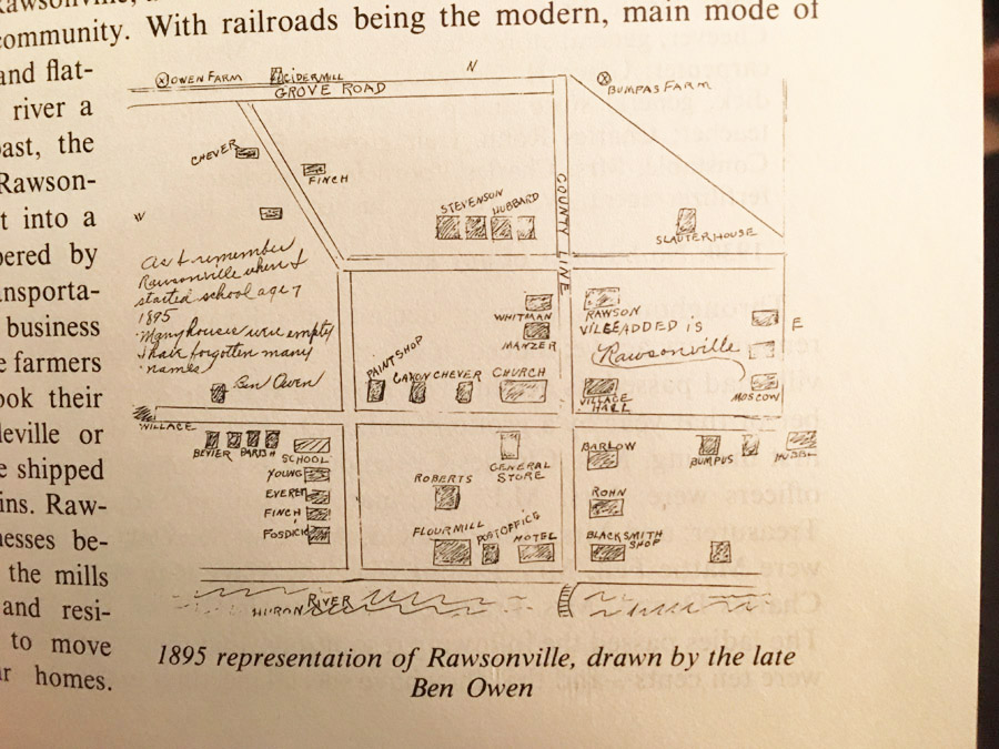
Sadly, I have yet to find other photos that would allow us to extend our stroll through 1890 Rawsonville. However, if we fast-forward a few years, there does exist a map that can tell us something about the neighborhood we have been seeing. The 1976 edition of the history book Water Under the Bridge included a map drawn from memory by a man named Ben Owen. In the margin, he notes that “many houses were empty,” even in 1895.
In fact, Rawsonville’s reputation as a deserted place extends this far back, and farther. Below we see a local newspaper article from 1895, when Ben Owen was still laying down his childhood memories, and it seems that Rawsonville was already well on its way to its future tenure as a ghost town:
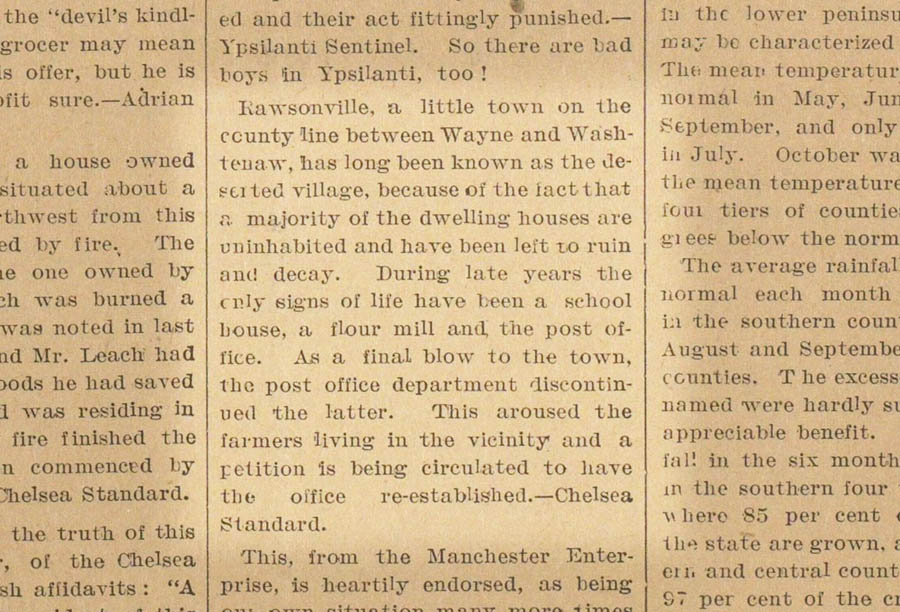
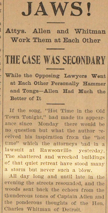
Then in 1897, in a different newspaper, we see an offhand reference to the “shattered and wrecked” buildings of Rawsonville, further suggesting that the status of Rawsonville as a deserted place was already common knowledge.
The fruits of neglect
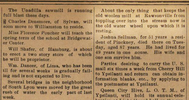
In March of that year, yet another local newspaper had found it newsworthy to mention that the Rawsonville woolen mill was in a precarious situation, after a series of spring rains that had also washed out bridges in South Lyon.
“About the only thing that keeps the old woolen mill at Rawsonville from toppling over into the stream now is the old water wheel upon which it is resting.”
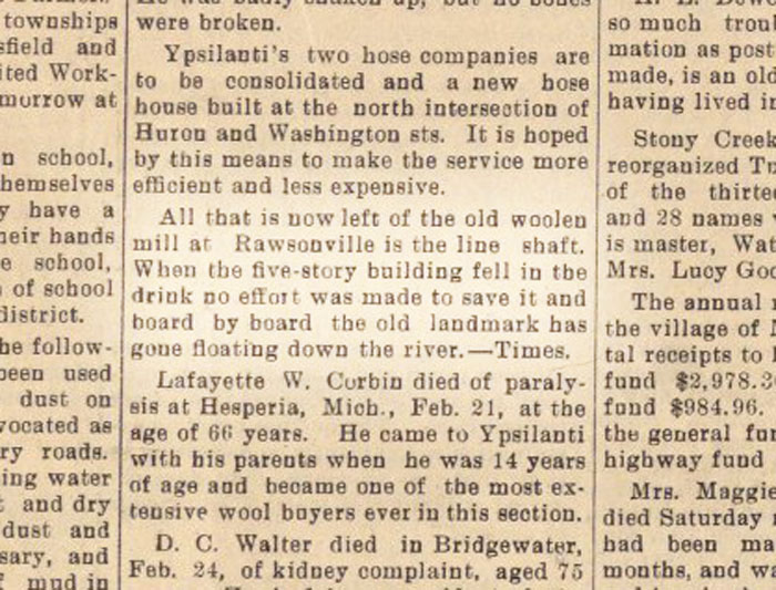
This observation would prove prescient. Almost exactly a year later, the end finally came:
“All that is now left of the old woolen mill at Rawsonville is the line shaft. When the five-story building fell in the drink no effort was made to save it and board by board the old landmark has gone floating down the river.”
An object of curiosity
If Rawsonville was already widely understood as “the deserted village” by 1895, and some of the more spectacular events of its decline were continuing to make the papers, then human nature tells us that it must have enjoyed some notoriety as an object of curiosity. Did history buffs, scavengers, and other weird characters go on outings from Ypsilanti or Belleville, to go poking around this decaying ghost town?
This perspective might help us interpret a mysterious set of photos brought to our attention by another reader, Mike, who encountered them in the online holdings of the Detroit Public Library. They are undated, and there is no way to tell the order in which the photos were taken, but we can get a sense of the approximate period by the handwriting, the size of the prints, and the style of mounting. I would guess that they date to roughly 1910, give or take a decade.
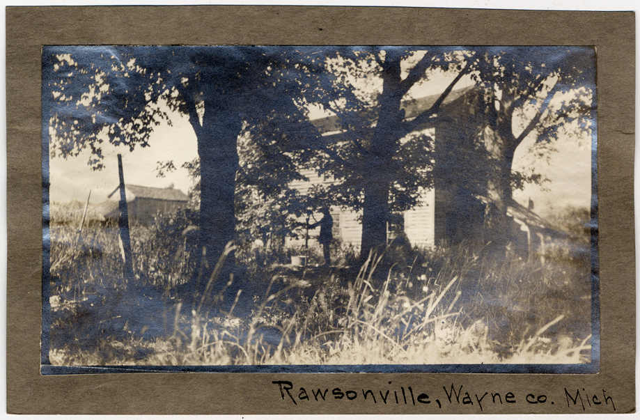
In the first image that I’ve selected below, we see three men posing for the camera, half a block south of Snow Road. What brings them, and their bulky Kodak, to the “quiet retreat” of Rawsonville?
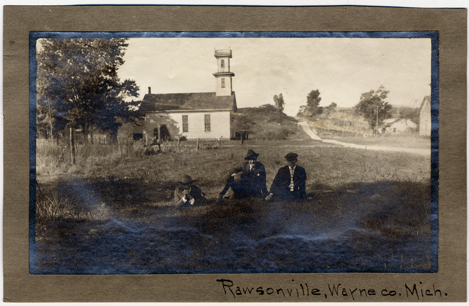
Behind them is the old Rawsonville church, and further behind, what is now Rawsonville Road climbs the hill rather steeply northward, toward Grove Road. We also see that the church steeple, which looked so grand and gleaming in the background of the 1890 photo, is not all that grand after all.
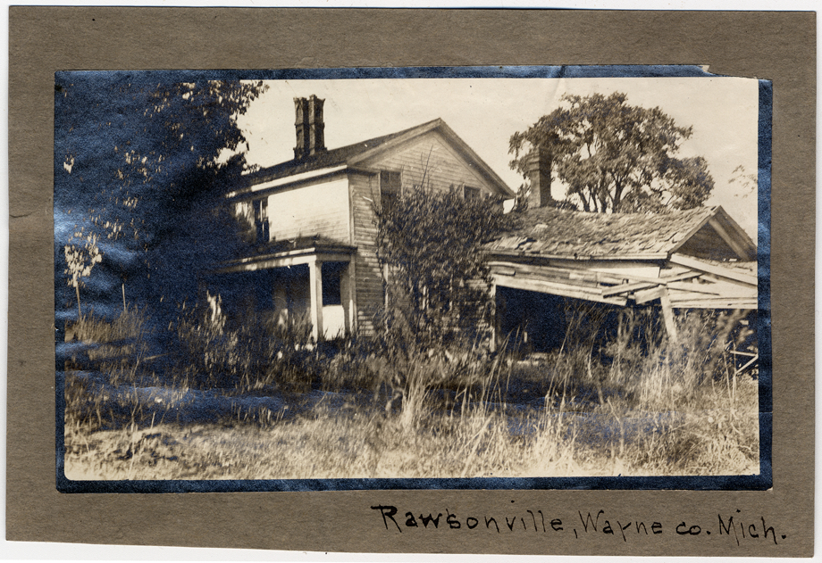
Next, our visitors have curiously devoted a frame to a view of a collapsing shed. The lawn seems a bit unkempt — perhaps the house is also abandoned. Is this one of Rawsonville’s uninhabited houses, “left to ruin and decay”?
As we look at more of the collection, it’s apparent that these photos have an odd air about them. There doesn’t seem to be any specific subject in most of them, and all of the scenes suggest an overgrown and neglected place. Of course, we can’t really be sure why they were taken, but they seem like just the type of photos that would result from a visit by a group of curiosity seekers.
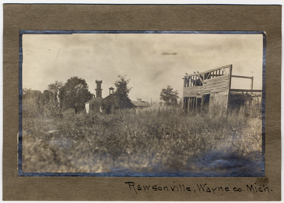
Next we see the wooden skeleton of a derelict building in an overgrown field. Rawsonville church is again in the background, and possibly the cupola of the community hall across the street. So this view faces west from somewhere east of Rawsonville Road, toward Snow Road.
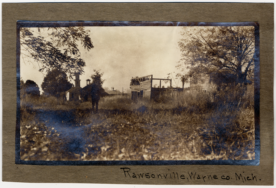
In another frame, the view widens to include an apparently abandoned building to the right of the wooden hulk, and a person who we can’t make out, standing in the view.
Below, a man operates a hand pump in what seems to be an overgrown side yard. Although there appears to be a water tub or similar object next to the pump, I’d speculate that the well is long abandoned, and the man is simply creating a whimsical scene for the camera as he attempts to pump some life into it.
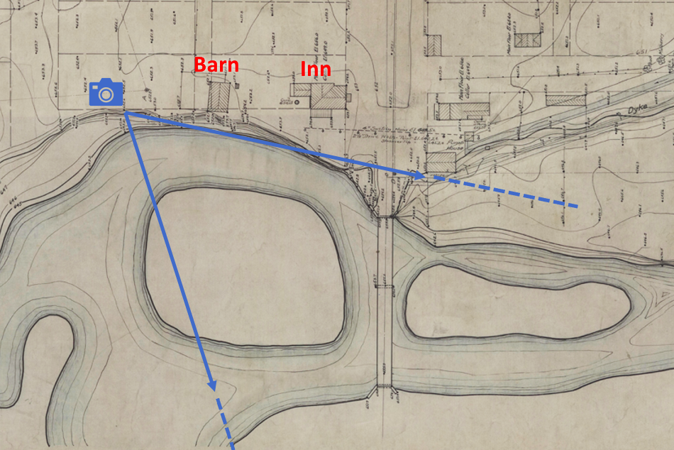
Finally, one of the frames is devoted to a peaceful scene on the Huron River. It gives us a peek at the old bridge and one of its abutments. Looking at old maps, based on the orientation of the river bend to the bridge, this must have been taken from the north bank, facing east toward the bridge. The photographer would have been standing, perhaps, somewhere near the barn at the rear of the old Rawsonville Inn, near the former location of the grist mill. The trees at center are likely growing on a small island or sandbar, that early maps suggest existed there before the river was raised somewhat by the creation of the lake.
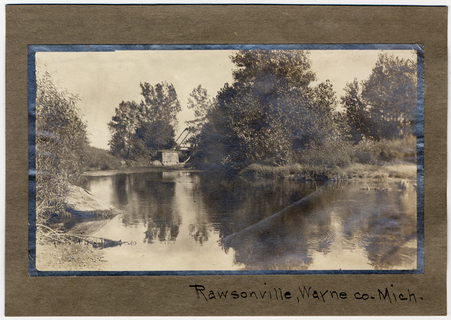
The 1922 survey map below shows what is possibly the camera location and view.
Rawsonville Inn, or Tavern
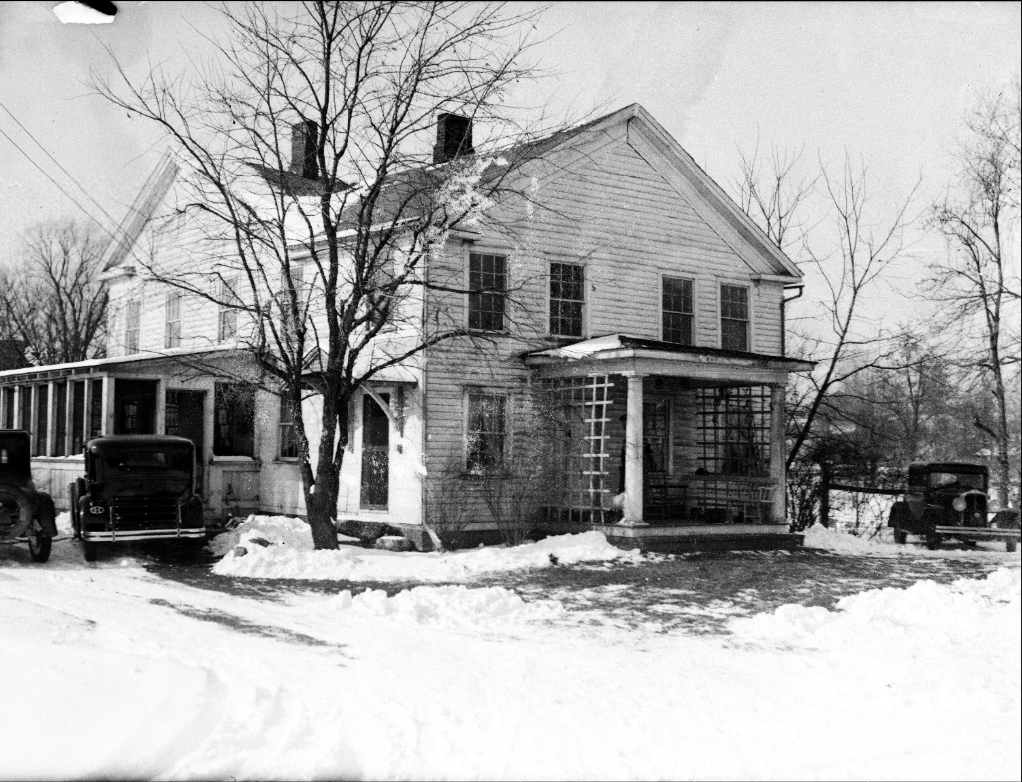
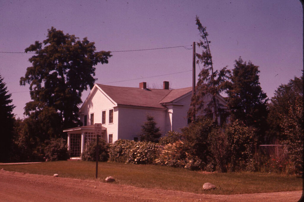
Speaking of the Rawsonville Inn, its building survived much longer than the rest of the town. By the 1930s, it had been purchased by Henry Ford, who had taken an interest in Rawsonville as he was purchasing neighboring land for the Ford Lake reservoir and at Willow Run. The photo below, which the reader Mike also found at Wayne State University, is dated to 1932. This source and other sources suggest that the upstairs was devoted to square dance lessons at the time, as Ford was said to be fond of preserving the quaint customs of the country folk.
Finally, I located another photo below from the Ypsilanti archives, showing the Inn/Tavern as a private residence in approximately 1963, shortly before it was demolished to free up additional right-of-way for the widening of Rawsonville Road.
Thus it seems that Rawsonville’s tenure as a ghost town has by now been much longer than its tenure as a town. For at least the last fifty years, only a few of its original houses have remained, and none of its more significant buildings. The area on either side of Rawsonville Road has also undergone a large amount of grading, as a modern bridge was constructed at the Huron River, and the approaches to the river valley were flattened; in addition, much of what was old Jefferson Street to the east of Rawsonville Road has been obliterated by dikes and ditches dug in the 1920s as the French Landing dam, which would create Belleville Lake, was being contemplated.
Thus it remains very hard for passersby to accurately imagine the little town that lingered here so long ago. Hopefully, these images can bring us one step closer to stepping into the scene — and more accurately connecting the present we know, to the past that we can otherwise only imagine.
Article Copyright 2022 by the author.
To be notified of new articles, visit https://whatshallweweird.com/subscribe/


10 Comments
William J Eyler
I enjoyed this article very much! It is eloquently written and the description of the camera perspective was especially helpful. The information on this topic as you are well aware, has been rare. The photo from Pam’s grandmother is an absolute gold mine! I’m so thankful for it and for the zoomed images and your description of the buildings. The alteration of the valley, bridge and grade makes it difficult to envision without these aids.
I grew up in Augusta Township due south of this place and have lived in Van Buren Township for more than 30 years. I’m an avid history seeker, mainly of local nature. This topic has been a bit frustrating because of the lack of documentation from the era. I have a copy of Water under the Bridge and some other works related to Lincoln Schools that don’t seem to be easily found. I’m currently in the conceptual stage for a book that will capture what I hope is a unique historical take before it’s gone, just as you have mentioned in some of your other pieces. This is the best written summary and best researched I’ve yet to see on this topic. Thank you for the excellent work!
Melissa Tingstad
We currently own the home located where the church was. The northwest corner or Rawsonville and Snow. Do you know if the church was demolished, or is our home a converted church? I have tried to find any history on our home, which dates back to the 1920s, with the original structure being 1893. Any information you have would be amazing!!! This was a GREAT article, thank you for giving us a glimpse into the past.
Mike
Hi Melissa, according to the book Water Under the Bridge it seems that the old church was torn down in 1962, at the same time the old Inn was torn down. I think it was because when the road was widened, the buildings would have been too close to the road. The book doesn’t have a profile of your house, unfortunately. But your property is composed of lots 92, 93, and 106 of old Rawsonville. You can see those on the maps at the other article, https://whatshallweweird.com/1477/old-rawsonville-setting-the-record-straight/
The east half of those lots was vacated for the right of way, and I think the church would have been on the east half of lot 106 right at the corner. Hope this helps!
William J Eyler
Hi Mike, How were you able to locate the aerial shots used in your article re: the grove of trees remaining at Rawsonville and 94? That was an amazing addition. I didn’t know anything like that existed. Also, do you have an e-mail where I can send some follow up questions for research I’m doing?
Mike
William, the aerial photos in that article came from the MapWashtenaw site https://gisappsecure.ewashtenaw.org/mapwashtenaw/
which shows property records for Washtenaw County. I’ve updated that article with a link to the site, under the 1940 photo. Once having zoomed in to Rawsonville, you can click the “Layers” button at lower left to select Aerial Photos. It’s a little tricky because if you’ve selected multiple dates for the aerial photos, the most recently dated set is the one that is visible, so select only one. But all the aerials in that article are from that site. I will contact you separately by email for your other questions. Thanks!
Mike
William, I wrote to the hotmail address that was in your comment post but did not get an answer. If you still want to ask any questions, please send an email to me at the address shown on the “About” page at https://whatshallweweird.com/about-2/
Pingback:
James Doemer
When I was a boy, from the 3rd Grade to the 6th Grade 1966 through 1969, I went to Rawsonville Elementary. At that time there was an old block structure, and a newer, larger, buillding. Of course, that has all been torn down and replaced. However, even at that time I was told that none of that was the original Rawsonville School. Are their pictures of the original school?
Mike
James, thanks for the comment. When writing the article I ran across a link that seems to show some pictures of the old school:
https://aadl.org/taxonomy/term/124913
Cindy
I lived on Snow Rd. for 25 years, very interesting history!!